Classic Maya Collapse Mystery: One City Didn't Even Have Drought
Tikal and Copán emptied by 900 CE, population fell 90%. Now a 2025 lake-sediment study found one city collapsed with no drought at all. So why did it fall?
The chisels stopped. Sometime in the ninth century CE, in the rainforests of what is now Guatemala, Belize, and southern Mexico, one of the most brilliant societies the ancient Americas ever produced simply quit building. These were people who raised limestone pyramids by hand, charted the wanderings of Venus across the night sky, and carved their kings' triumphs into stone with mathematical dates so precise we can still read them. Then, one city at a time, the carving stopped. The plazas emptied. Within a few generations the great urban centers of the southern lowlands sat silent under the trees, swallowed by green — joining the roster of lost cities the earth swallowed whole. For decades drought looked like the answer. Then a 2025 lake-sediment study found a city that collapsed with no drought at all. What happened to the Maya is one of archaeology's most stubborn puzzles, and here's the honest part: nobody has cracked it.
> The 60-Second Brief
> - Population in the Central Maya Lowlands fell close to 90 percent, and the region stayed nearly empty for over 1,000 years (PNAS, Turner & Sabloff 2012).
> - Tikal carved its last Long Count date in 869 CE; no securely dated lowland monument exists after ~910 CE (World History Encyclopedia).
> - A 2018 Cambridge/University of Florida study measured rainfall down 41–54 percent (up to 70 percent at peak) during the collapse (Science 2018).
> - A 2025 stalagmite record found droughts as long as 13 years between roughly 871 and 1021 CE (Science Advances 2025).
> - A 2025 lake-sediment study of Laguna Itzan, Guatemala, found stable climate during the very period that city's population collapsed — direct evidence against drought as a universal cause (Biogeosciences 2025, via ScienceDaily).
> - Northern cities like Chichén Itzá and Uxmal thrived into the Postclassic, some past the 11th century — the Maya did not disappear (Mexico News Daily).
What We Actually Know
Start with the timeline, because that part is solid. The Classic period of Maya civilization runs roughly 250–900 CE, and its last gasp, around 800–900 CE, has a name: the Terminal Classic (World History Encyclopedia; Lumen Learning / SUNY). In that window, the great cities of the southern and central lowlands, Tikal, Palenque, Copán, Calakmul, slid into decline and were mostly left to the jungle (PNAS, Turner & Sabloff 2012).
The clearest fingerprint of the collapse is written in stone. The Maya tracked time with the Long Count calendar, and Classic-era rulers carved those dates onto stelae to mark their crownings, their victories, their rituals. Then, across the lowlands, the habit faded and died. Tikal carved its last known Long Count date in 869 CE, and no securely dated lowland monument is known after about 910 CE (World History Encyclopedia). The silence wasn't only on the stelae. Archaeologists watch the monumental building stop, the royal dynasties vanish, the fine elite goods dry up, and the wars between cities flare hotter (Penn State / Latin American Antiquity).
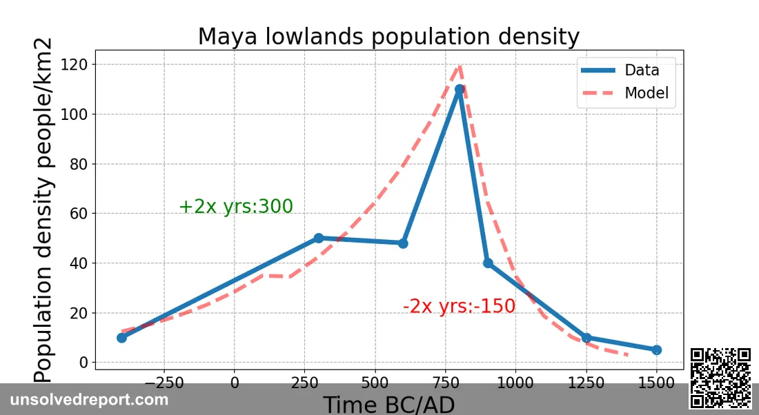
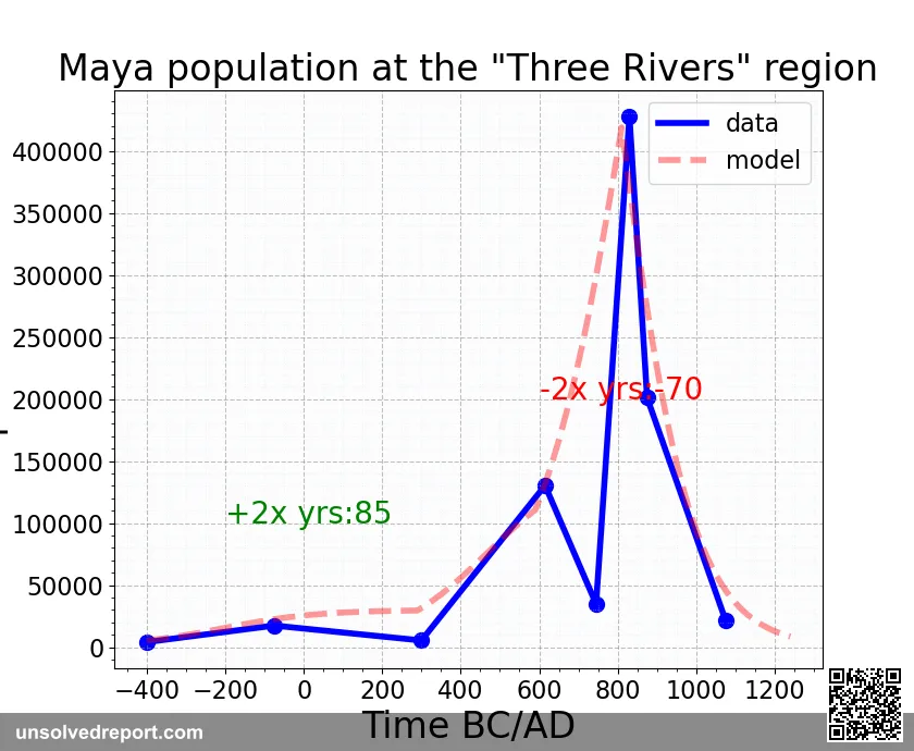
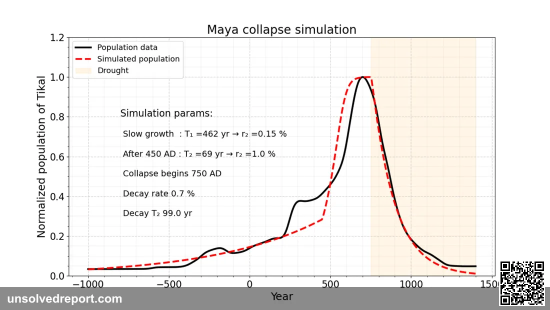
And the scale is staggering. A vast machine of cities, reservoirs, and carefully managed farmland across the Central Maya Lowlands was essentially walked away from. Population crashed by something close to 90 percent, and the region stayed nearly empty for more than a thousand years afterward (PNAS, Turner & Sabloff 2012).
Then there's the weather, and this is where the story gets a hard edge. In 2018, researchers from the University of Cambridge and the University of Florida found a way to measure ancient drought directly: they read the isotopes of water locked inside gypsum crystals pulled from Lake Chichancanab, in Mexico's Yucatán. The verdict was brutal. During the collapse, yearly rainfall dropped somewhere between roughly 41 and 54 percent compared with today, plunging as much as 70 percent at the worst of it, while relative humidity fell 2 to 7 percent (University of Cambridge; Evans et al., Science 2018). A separate record, this one from stalagmites in a cave in northwest Yucatán, tells the same grim tale from a different angle: a run of droughts, some stretching as long as 13 years, between roughly 871 and 1021 CE (Science Advances 2025).
The Part Nobody Can Explain
Here's the strange part. We know that the cities fell silent, and we know roughly when. What we don't have is the why, not one cause everyone agrees on. And the Maya, frustratingly, barely mention it. As the World History Encyclopedia puts it, "the inscriptions left by the Maya themselves are strangely silent on the topic" (World History Encyclopedia). Their monuments brag about kings and conquests. They say almost nothing about a civilization quietly coming undone.
It gets murkier. The collapse wasn't one event, and it wasn't everywhere. Different regions fell at different times, sometimes more than a century apart, shrinking back toward a few surviving strongholds (Penn State / Latin American Antiquity). And here's the correction that overturns the whole pop-culture version of this story: the collapse was not the end of the Maya. While the southern lowland capitals emptied out, cities up in the northern Yucatán, Chichén Itzá, Uxmal, Cobá, were thriving deep into the Postclassic, with some northern centers holding on until the 11th century or later (Mexico News Daily). Newer settlement work using lidar even suggests rural populations in parts of northern Yucatán stayed remarkably steady for centuries while elite capitals rose and crumbled around them (National Geographic). Millions of Maya people live in the region right now. So forget "where did everyone go." The real riddle is narrower, and weirder: why did this one specific, crowded web of southern lowland cities, with all their political muscle and engineering genius, become impossible to sustain, when the countryside and the northern cities carried on just fine?
The Leading Suspects
A warning before the lineup: every explanation below is something scholars weigh and blend together. None is a closed case.
Drought (strong physical evidence, fought over as the lone culprit). The lake and cave records make decades of drying during the Terminal Classic hard to argue with. The trickier leap is saying drought caused the collapse, and that's exactly where archaeologists pump the brakes. The disruption played out so unevenly across the map that a single regional climate signal can't tidily account for all of it (Science 2018 search summary; PNAS, Kennett & Beach 2015) — the same evidentiary trap that has kept theories of why Mohenjo-daro was abandoned unsettled for a century.
Too many people, too much strain (interpretation). Some researchers think Late Classic cities were packed far more tightly than we used to assume, and that hard farming, cleared forests, and worn-out soil left the whole system fragile, ready to snap the moment the rains failed (World History Encyclopedia) — the same overgrowth-then-implosion pattern researchers argue over at Cahokia, the North American city that briefly outgrew London. But local stories refuse to line up neatly. One study at Copán, in Honduras, actually found evidence against deforestation as that city's undoing (PNAS, McNeil et al. 2010).
Endless war and political splintering (interpretation). The Terminal Classic crackles with rising conflict between rival city-states, not unlike the wave of raids and burned palaces that mark the Sea Peoples' Bronze Age collapse half a world away. The open question is which way the arrow points: was escalating warfare driving the collapse, or just a symptom of something deeper, like a brawl over shrinking resources? Still up for debate (Penn State / Latin American Antiquity).
The trade map redrawn (interpretation). Trade routes shifted, and coastal and river commerce grew more important, favoring other centers. That re-routing may have quietly knocked the economic legs out from under the inland southern cities (PNAS, Turner & Sabloff 2012).
So where does that leave us? Not with one villain, but with a pile-up. Picture a society wound tight, a cluster of rival kingdoms pushing their land to its limit, then slammed by decades of savage drought, until the political glue holding it all together finally let go, unevenly, over something like 150 years. The cities fell silent. The Maya did not vanish. And the exact mix of causes that hushed Tikal while Chichén Itzá blazed on is a question the rainforest is still, very slowly, giving up.
The Collapse at a Glance
Every figure below comes from the sources cited in the body of this article — no estimates added.
| Question | What the record shows | Source |
|---|---|---|
| When was the Classic period? | Roughly 250–900 CE | World History Encyclopedia; Lumen Learning / SUNY |
| When did the collapse happen? | The Terminal Classic, ~800–900 CE, unfolding unevenly over roughly 150 years | World History Encyclopedia; Penn State / Latin American Antiquity |
| Last securely dated lowland monument | ~910 CE | World History Encyclopedia |
| Population loss in the Central Maya Lowlands | Close to 90 percent, with the region staying nearly empty for over a thousand years | PNAS, Turner & Sabloff 2012 |
| How bad was the drought? | Annual rainfall down ~41–54% versus today, up to 70% at peak; relative humidity down 2–7% | University of Cambridge; Evans et al., Science 2018 |
| How long did droughts last? | A run of droughts between ~871 and 1021 CE, some as long as 13 years | Science Advances 2025 |
| Did the Maya disappear? | No — northern Yucatán cities like Chichén Itzá and Uxmal thrived into the Postclassic, some until the 11th century or later, and millions of Maya live in the region today | Mexico News Daily |
A Dated Trail of Evidence
The collapse wasn't a single moment, and neither was our understanding of it. Here is the sequence, ancient and modern, as the cited sources date it:
- ~250 CE — The Classic period begins in the Maya lowlands (World History Encyclopedia; Lumen Learning / SUNY).
- ~800 CE — The Terminal Classic opens: monumental building slows, dynasties falter, and inter-city warfare intensifies across the southern lowlands (World History Encyclopedia; Penn State / Latin American Antiquity).
- ~871–1021 CE — A stalagmite record from a northwest Yucatán cave registers a run of droughts, some lasting up to 13 years (Science Advances 2025).
- ~910 CE — The last securely dated lowland monument. After this, the stone record goes quiet (World History Encyclopedia).
- 11th century and later — Northern centers such as Chichén Itzá and Uxmal are still holding on, deep into the Postclassic (Mexico News Daily).
- 2012 — Turner and Sabloff's PNAS synthesis frames the collapse of the Central Maya Lowlands as a roughly 90 percent population loss followed by a millennium of near-abandonment (PNAS, Turner & Sabloff 2012).
- 2018 — Cambridge and University of Florida researchers read water isotopes in gypsum from Lake Chichancanab and put hard numbers on the drought: rainfall down 41–54 percent, up to 70 percent at its worst (University of Cambridge; Evans et al., Science 2018).
- 2024 — New lidar-informed settlement research suggests rural populations in parts of northern Yucatán stayed steady for centuries while elite capitals rose and fell — sharpening the question of what, exactly, "collapsed" (National Geographic).
Weighing the Suspects: How Strong Is Each Case?
No new facts here — just an honest scorecard of the four explanations laid out above, and what it would take to settle each one.
| Explanation | Strength of evidence | Weak point | What would move the needle |
|---|---|---|---|
| Drought | Strongest physical record: independent lake-gypsum and stalagmite data agree on severe, prolonged drying (Evans et al., Science 2018; Science Advances 2025) | A single regional climate signal can't explain why different areas fell as much as a century apart (Penn State / Latin American Antiquity) | City-by-city climate records precise enough to match each center's decline against local rainfall |
| Overpopulation / environmental strain | Plausible interpretation of dense Late Classic settlement (World History Encyclopedia) | Contradicted locally: at Copán, evidence argues against deforestation as the cause (PNAS, McNeil et al. 2010) | More site-level soil and pollen studies — Copán shows one site can overturn the regional story |
| Warfare / political fragmentation | Warfare's "intensification and scale increased prior to the collapse," to the point that cities began building fortifications (World History Encyclopedia) | Cause or symptom? Warfare could be the driver or a downstream effect of scarcer resources | Evidence on timing: did conflict escalate before or after the ecological stress set in |
| Trade-route shift | Fits the pattern of inland southern cities losing out as coastal and river commerce grew (PNAS, Turner & Sabloff 2012) | Largely inferential — hard to show re-routed trade alone could hollow out a capital | Tracing traded goods to date exactly when southern cities dropped out of exchange networks |
The scorecard explains why specialists talk about a pile-up rather than a culprit: the explanation with the hardest data (drought) has a geography problem, and the explanations that fit the geography rest on interpretation. That mismatch — not a lack of evidence — is what keeps the case open.
The Scale of the Abandonment, in Hard Numbers
The tables above track when and why. These figures, all from the World History Encyclopedia's account of the collapse, measure how much was actually walked away from — and who was doing the walking (World History Encyclopedia):
- 60,000 square miles. "After the collapse, the 60,000 square miles of the Maya lowlands was deserted." That is the physical footprint of the silence — an area larger than many modern countries, left to the forest.
- From 830 CE, the cranes stopped. "From 830 no new buildings were constructed in the central Maya area." Construction — the most expensive thing a Maya king could order — halted decades before the last dated monuments were carved, a leading indicator that royal power was failing before the stone record went quiet.
- c. 760–910 CE. The same source frames the collapse not as an event but as "a process of decline which occurred over a period of 150 years between c. 760 and c. 910" — pushing the starting line back earlier than the conventional ~800 CE opening of the Terminal Classic.
- Droughts from c. 800 to c. 1050. Its reading of the climate evidence — "a sustained series of droughts between c. 800 and c. 1050" — brackets and overlaps the independent stalagmite record of droughts between ~871 and 1021 CE (Science Advances 2025). Two different dating routes converge on the same brutal window.
- 90 percent were farmers. The society that abandoned those cities was overwhelmingly agricultural — which is why decades of failed rain strikes at the base of the pyramid, not just its royal apex.
- Seven million. "Even today seven million people speak Mayan in Mesoamerica." Whatever collapsed in the ninth century, it was a political and urban order — not a people.
The 2025 Twist: A City That Never Saw Drought
Most of the drought evidence above comes from lake and cave records in the Yucatán. In 2025, a team led by Benjamin Gwinneth at the Université de Montréal, publishing in Biogeosciences, took a different approach: they read 3,300 years of sediment from Laguna Itzan, a lake beside a Classic Maya city in Guatemala, tracking fire intensity (via polycyclic aromatic hydrocarbons), rainfall (via leaf-wax hydrogen isotopes), and population (via fecal stanols) layer by layer (ScienceDaily, reporting the Biogeosciences study).
The result complicates the drought narrative directly: Itzan's climate stayed stable through the Terminal Classic (roughly 1,140 to 1,000 years ago) even as its population collapsed. This is thematically related to, not a new discovery about, Tikal or Copán specifically — Itzan is a separate southern lowland city, and the study speaks to the collapse's regional variability rather than overturning the drought evidence at other sites. The researchers argue the real mechanism was interconnection: drought hitting the central lowlands could have triggered cascading warfare, migration, and trade disruption that dragged even climatically stable cities like Itzan down with it. It is a fresh, dated data point for the "pile-up, not one villain" reading already laid out above — not a reversal of it.
Frequently Asked Questions
Did the Maya civilization go extinct?
No. The Classic-period collapse hit the southern lowland cities — Tikal, Copán, Calakmul — but northern Yucatán centers like Chichén Itzá and Uxmal thrived into the Postclassic, some past the 11th century, and roughly seven million people speak Mayan languages in Mesoamerica today (Mexico News Daily; World History Encyclopedia).
Was drought the main cause of the Maya collapse?
Drought is the best-documented physical factor — independent lake-gypsum and stalagmite records agree on severe, prolonged drying during the Terminal Classic (Science 2018; Science Advances 2025). But a single regional climate signal can't explain why different cities fell up to a century apart, and a 2025 study found at least one city, Itzan, collapsed under stable climate conditions (ScienceDaily). Most specialists treat drought as one trigger among several, not the sole cause.
How long did the Maya collapse take?
It was not one event. The World History Encyclopedia frames it as "a process of decline" running roughly 760 to 910 CE, about 150 years, with different regions falling at different times (World History Encyclopedia).
What happened to Tikal specifically?
Tikal carved its last known Long Count date in 869 CE. Construction had already slowed decades earlier — the World History Encyclopedia notes no new buildings went up in the central Maya area after 830 CE — and no securely dated lowland monument survives after about 910 CE (World History Encyclopedia).
Did warfare cause the collapse, or result from it?
Both are argued. Warfare's "intensification and scale increased prior to the collapse," to the point that cities built fortifications (World History Encyclopedia). Whether escalating conflict drove the collapse or was itself a symptom of resource scarcity remains an open question in the literature (Penn State / Latin American Antiquity).
Why don't Maya inscriptions explain the collapse?
Classic-period monuments were built to record royal triumphs — coronations, victories, ritual dates — not administrative decline. As the World History Encyclopedia puts it, "the inscriptions left by the Maya themselves are strangely silent on the topic," which is why the reconstruction relies on archaeology and climate science rather than the Maya's own written record (World History Encyclopedia).
Every leading theory here has real evidence and a real hole in it. The 2025 Itzan data does not close that gap — it widens it, by showing the same collapse pattern can show up with or without a local drought. Until researchers can match city-by-city climate records against city-by-city abandonment dates, the honest answer to "why did the Maya collapse" stays what it has been for decades: probably all of the above, unevenly, and not yet provable which factor mattered most where.
Sources & Further Reading
- University of Cambridge — Scientists measure severity of drought during the Maya collapse
- Evans et al., Science (2018) — Quantification of drought during the collapse of the classic Maya civilization
- Turner & Sabloff, PNAS (2012) — Classic Period collapse of the Central Maya Lowlands
- Douglas et al., PNAS (2015) — Drought, agricultural adaptation, and sociopolitical collapse in the Maya Lowlands
- McNeil et al., PNAS (2010) — Evidence disputing deforestation as the cause for the collapse of Copán
- Science Advances (2025) — Classic Maya response to multiyear seasonal droughts in Northwest Yucatán
- World History Encyclopedia — The Classic Maya Collapse
- National Geographic — New research challenges the idea that the Maya civilization collapsed
- Penn State / Latin American Antiquity — Terminal Long Count dates and the disintegration of Classic Period Maya polities
- Gwinneth et al., Biogeosciences (2025), reported by ScienceDaily — Maya collapse mystery deepens as scientists find no drought at key site
Cleopatra's Tomb: The 20-Year Hunt That Found Everything But Her
A lawyer-turned-archaeologist has spent 20 years hunting Cleopatra's tomb at Taposiris Magna—finding coins, a tunnel, a sunken port. So where is she?
Costa Rica's Stone Spheres: The Balls the Bulldozers Almost Erased
Costa Rica's stone spheres: carved without metal tools, unearthed on a banana plantation, then dynamited by treasure hunters. What were they really for?
Shigir Idol Mystery: The 12,500-Year-Old Face No One Can Read
The Shigir Idol mystery: gold miners pulled this 12,500-year-old wooden god from a Russian bog. It's covered in faces nobody can read. What is it hiding?