Catalhoyuk No Streets Mystery: A 9,000-Year Town With No Doors
No streets. No doors. No alleys. Just rooftops and ladders for 9,000 years — and archaeologists still can't agree why. Here's the evidence, ranked.
You want to visit a neighbor. So you climb a ladder to your own roof. You walk across their roof. Then you drop through a hole in their ceiling and land in their living room. There is no front door. There is no street to walk down. There is no alley, no road, no path at ground level anywhere in the whole town — just mudbrick houses jammed wall to wall, and a sea of rooftops overhead doing the job that roads do everywhere else.
This was an ordinary afternoon at Catalhoyuk, in central Turkey, about 9,000 years ago. And it leaves us with one of archaeology's most stubborn questions: who builds a town like this, and why?
What we actually know
Catalhoyuk (say it roughly "cha-tal-hew-yook") sits on the Konya Plain in south-central Turkey — the same region that would later hide the vast underground refuge at Derinkuyu — and it is staggeringly old. People lived here from about 7400 to 5600 BCE, with the first house going up sometime between 7400 and 7100 BCE (World History Encyclopedia). Sit with that for a second. The earliest layers of this town are older than the pyramids of Egypt by thousands of years — and older than writing itself, built not long after nearby Gobekli Tepe went up on the other side of Anatolia. There were no words yet to record any of it. In 2012, UNESCO added it to the World Heritage List as the "Neolithic Site of Catalhoyuk" (UNESCO).
How many people lived here? Estimates differ, but archaeologists generally put the peak somewhere between about 3,500 and 8,000 residents (World History Encyclopedia). That is an astonishing crowd for the Neolithic — so big that researchers keep reaching for the word "proto-city" to describe it. Thousands of people, in one place, before the wheel, before the alphabet.
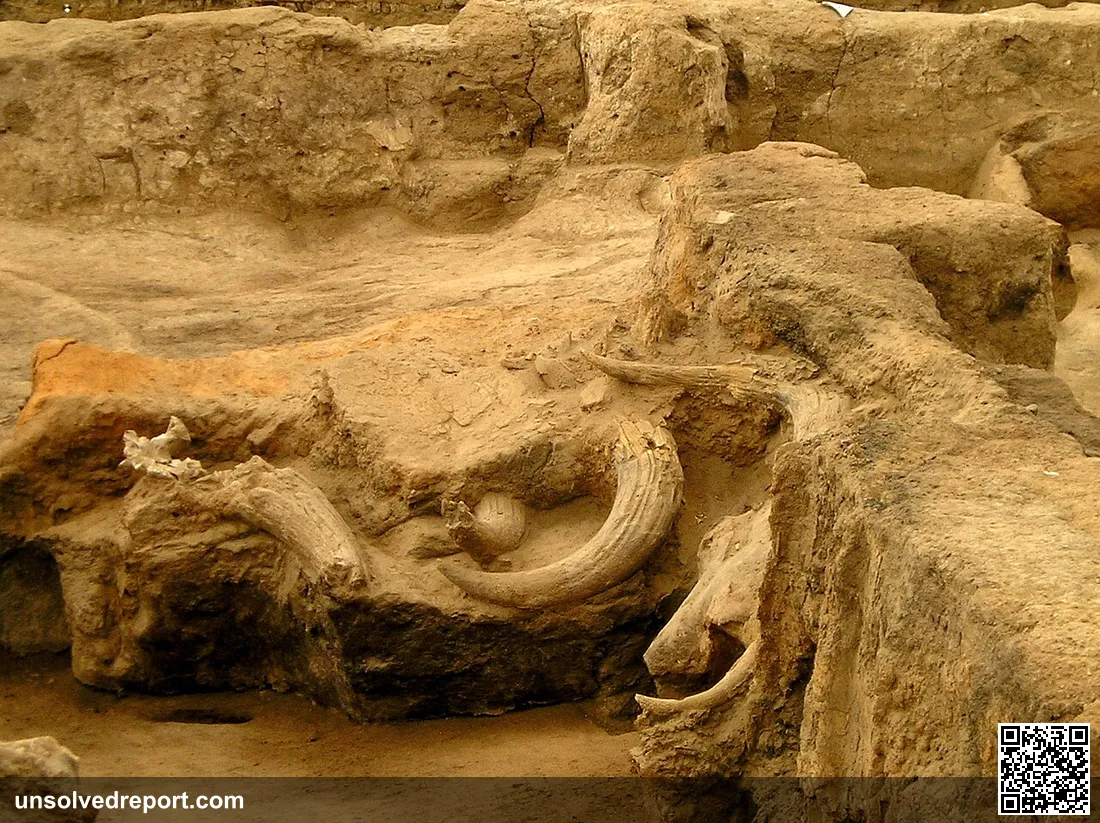
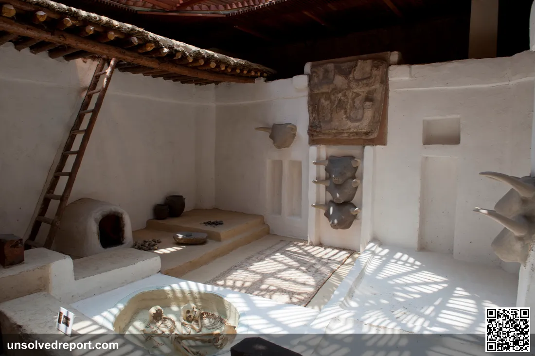
Now the part that stops everyone in their tracks: the buildings. The houses were roughly rectangular, made of mudbrick, and shoved directly against one another with no streets or passages in between (Catalhoyuk Research Project). Picture it like a honeycomb pressed flat. Because the homes abutted and stacked, the roofs became the town's open-air streets. The World History Encyclopedia puts it plainly: the houses were "piled up on top of each other, row by row, so that the roofs of lower houses also served as courtyards and pathways." And every roof had a big opening — usually right above the oven-hearth on the southern side of the room. That single hole did everything at once. It let the smoke out. It let light and air in. And it was the front door: you climbed down a wooden ladder to get home (World History Encyclopedia; Catalhoyuk Research Project).
Step inside, and the houses are eerily alike. Walls and floors were finished in clean white plaster, sometimes painted with hunting scenes, geometric patterns, and wild animals (Catalhoyuk Research Project). Raised platforms ran along the rooms for sleeping and working — and here is the strange part: underneath those platforms, the people buried their dead (Catalhoyuk Research Project). You slept, ate, and lived directly above your ancestors. Houses were periodically filled in, sometimes burned, and then rebuilt on the exact same spot, generation after generation. Do that for centuries and the whole mound rises higher and higher — which is why the site stands so tall today.
One absence is louder than anything present. There are no palaces. No towering temples. No grand tombs looming over the neighborhood. The homes are broadly the same size, the same layout, with no single building set apart as the seat of power (Smarthistory; World History Encyclopedia). In a town of thousands, nobody's house got to be the big one — a puzzle not unlike why Mohenjo-daro was abandoned with barely a power structure in sight.
And recently the DNA has spoken. An international team — including longtime Catalhoyuk researcher Ian Hodder — published work in the journal Science analyzing the genomes of 131 individuals from 35 houses, as reported by Al Jazeera. The pattern was striking: female offspring tended to stay tied to the same buildings across generations, hinting at a matrilineal line, and young females were buried with noticeably more grave goods than males (Al Jazeera). Hodder summed up the bigger picture as "strong evidence of social egalitarianism," while adding that females "played a central role but not a dominant role" (Al Jazeera).
The question nobody can answer
So here it is, the thing that still has no answer: why did thousands of people choose to live in a town with no streets, climbing into their own homes through the roof?
And before you write it off as a quirk — no, this wasn't an accident. The houses were deliberately built wall-to-wall, over and over, for centuries. Whatever drove the design, it was a stable, repeated, intentional choice made by generation after generation. But no inscription explains it, because writing didn't exist yet. Every theory we have is reconstructed from walls, graves, and paintings — never from the words of the people who actually lived there. There's a deeper version of the puzzle, too, and scholars are still arguing about it: could a packed settlement of several thousand people really run itself with no central authority? Or does the very absence of palaces and temples just hide a layer of social rules and coordination we can't detect in the dirt? That's the tension at the heart of it all — a town that looks flat and equal, doing all the crowded, complicated work of keeping thousands of people fed, housed, and organized.
The leading theories
What follows are readings offered by researchers and observers. They're plausible takes on the evidence, not closed cases.
Theory 1: It was a fortress in disguise. Pack the houses together, leave the only entrances on the roofs, and the outer edge of town becomes a blank, windowless, doorless wall. An attacker arrives and finds nothing to grab onto — no gate, no street to charge down, just an unbroken face of mudbrick. It's a clean idea. The catch is that direct evidence of warfare at the site is thin, so treat this as one possibility among several rather than the answer.
Theory 2: Everyone equal, by design. Many scholars, Ian Hodder among them, argue that the uniform, interlocking houses both reflected and reinforced an egalitarian way of life — a town where no household could physically loom over another (Smarthistory). The matrilineal pattern and the grave-goods findings are sometimes read as backing up a fairly non-hierarchical society. Keep in mind: this is an interpretation drawn from patterns in the evidence, not a proven social fact.
Theory 3: It just made sense. The plainest reading is also the least romantic — abutting construction was simply an efficient way to keep adding homes as the population swelled. Shared walls save materials and labor. Rooftops hand you free public space. Under this view, "no streets" isn't a grand philosophy at all. It's just what happens when a crowded town keeps building, one house at a time, with no room to waste.
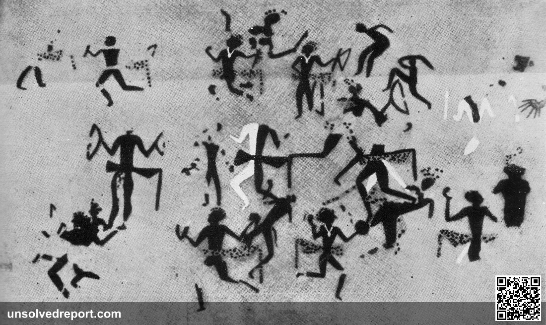
Bonus mystery: the world's oldest map? There's a roughly 9-foot wall painting from the site that some call the oldest map ever made — read as a bird's-eye view of the town beneath an erupting twin-peaked volcano, possibly Hasan Dagi (Sci.News). Other scholars look at the same mural and shrug: maybe it's just a decorative geometric panel topped by a leopard skin, no landscape involved (Biblical Archaeology Society). A map of a smoking volcano, or wallpaper. Both readings are still standing.
Nine thousand years on, Catalhoyuk still won't sit still. A town where the roof was the road, where the dead slept beneath the living, where nobody's house was bigger than anyone else's — and where the simplest question of all, why like this?, has yet to find its final answer. The people who knew left no words behind. So the rooftops keep their secret, and we keep climbing the ladder, looking for a way in.
Catalhoyuk at a glance
Every figure below comes from the sources cited in this article — nothing here is estimated or rounded beyond what the researchers themselves report.
| Fact | What the sources say | Source |
|---|---|---|
| Location | Konya Plain, south-central Turkey | World History Encyclopedia |
| Occupation span | c. 7400 to 5600 BCE | World History Encyclopedia |
| First houses | Built sometime between 7400 and 7100 BCE | World History Encyclopedia |
| Peak population | Roughly 3,500 to 8,000 residents | World History Encyclopedia |
| Streets and ground-level doors | None — houses built wall-to-wall; roofs served as courtyards and pathways | Catalhoyuk Research Project; World History Encyclopedia |
| How you got home | Through a roof opening above the oven-hearth on the room's southern side, down a ladder | World History Encyclopedia; Catalhoyuk Research Project |
| Where the dead went | Buried beneath the raised platforms inside the houses | Catalhoyuk Research Project |
| Palaces, temples, elite tombs | None identified — houses broadly uniform in size and layout | Smarthistory; World History Encyclopedia |
| DNA study scope | Genomes of 131 individuals from 35 houses, published in Science | Al Jazeera |
| Female lineage continuity | An estimated 70 to 100% of the time, female offspring remained connected to the same buildings | Al Jazeera |
| Grave goods gap | Young females, including infants, received up to five times as many grave goods as boys | Al Jazeera |
| UNESCO status | Inscribed on the World Heritage List in 2012 as the "Neolithic Site of Catalhoyuk" | UNESCO |
Weighing the theories: what the evidence actually supports
None of the theories above introduces new facts — they are competing readings of the same walls, graves, and paintings. So it's worth being honest about how much weight each one can actually carry.
The fortress reading rests on the architecture alone: a wall-to-wall town with roof-only entrances would present an attacker with a blank mudbrick face, and that's a real feature of the site. Its weakness is what's missing — the article's sources report no strong direct evidence of warfare at Catalhoyuk, so the defensive payoff is inferred from the design rather than demonstrated by destruction layers or battle casualties. What would strengthen it: unambiguous signs of attack in the excavated levels. Until then, it explains what the layout could do, not why it was built.
The egalitarian reading has the most converging support: uniform house sizes, no palaces or temples (Smarthistory), and now genomic and burial patterns from 131 individuals (Al Jazeera). Its structural weakness is the classic one: absence of visible hierarchy in the dirt is not proof that hierarchy was absent. Status can run through kinship, ritual, or seasonal roles without ever showing up as a bigger house. Hodder's own careful phrasing — "central role but not a dominant role" — signals how far the researchers themselves are willing to stretch the data.
The practical-efficiency reading is the hardest to falsify, which is both its strength and its problem. Shared walls genuinely save labor and material, and rooftop space genuinely substitutes for streets. But pure convenience struggles to explain the persistence the article's sources describe — houses filled in, sometimes burned, and rebuilt on the exact same footprint for generations (Catalhoyuk Research Project). That looks less like ad-hoc expansion and more like a rule people kept choosing to follow.
The honest summary: the egalitarian interpretation currently has the most evidence pointing its way, the efficiency explanation is compatible with everything but explains the least, and the fortress theory is waiting on evidence that hasn't turned up. Because the town predates writing, no future dig will hand us the inhabitants' own answer — only more patterns to argue over.
Sources and Further Reading
- UNESCO World Heritage Centre — Neolithic Site of Catalhoyuk
- World History Encyclopedia — Catalhoyuk
- Catalhoyuk Research Project — Architecture
- Smarthistory — Catalhoyuk
- Al Jazeera — Archaeologists find ancient matrilineal society in Turkiye's Catalhoyuk
- Sci.News — Catalhoyuk 'Map' Mural May Depict Volcanic Eruption
- Biblical Archaeology Society — Catalhoyuk Mural: The Earliest Representation of a Volcanic Eruption?
Lady of Elche: The Buried Face That Won't Stop Lying
A farmhand's tool hit stone in 1897 and a 2,400-year-old face stared back. Real Iberian icon or a clever Victorian fake? Scientists finally tested her paint.
Nebra Sky Disc: The Bronze Age Star Map Looters Nearly Erased
The Nebra Sky Disc may be the oldest star map on Earth — but looters buried its proof. Is it 3,600 years old, or a thousand years younger than we think?
The 520-Ton Stone Aksum Couldn't Stand Up
A 33-meter, 520-ton stone—the heaviest humans ever tried to raise—lies shattered in Ethiopia. Nobody knows how Aksum moved it, or why it fell.