Nazca Lines: Why Draw Giant Art Only the Sky Can See?
A desert people carved a hummingbird the size of a soccer field — then could never see it whole. Here's what we actually know about the Nazca Lines, and the riddle nobody has cracked.
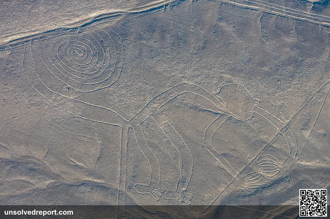
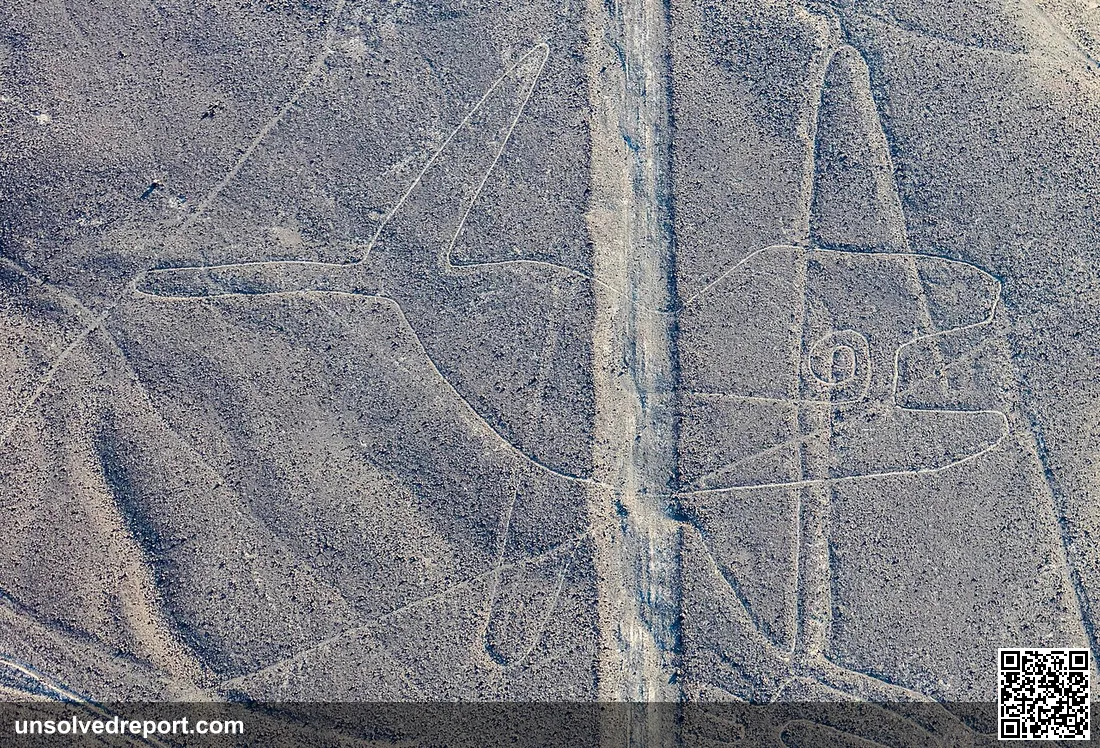
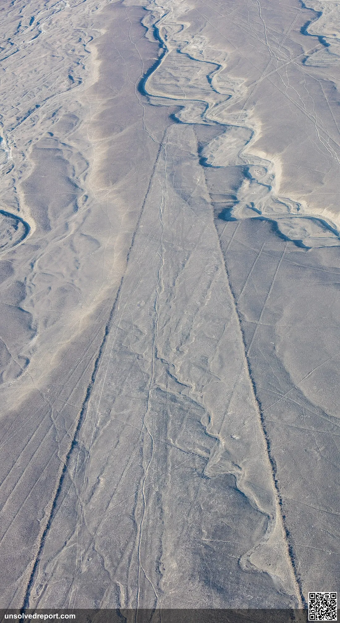
Stand on the desert floor of southern Peru and you'd walk right past them. The figures are simply too big to read from the ground — a hummingbird as long as a soccer field, a monkey with a tail curled into a spiral, lines that shoot dead-straight for miles across the flat, baking pampa. To see one whole, you have to climb a hill. Or do what travelers started doing in the 20th century: leave the ground entirely and fly.
And that's the whole problem in a single sentence. A desert people spent staggering, organized effort drawing pictures they could never fully see. The Nazca Lines mystery isn't whether they're real, or who scratched them into the earth — both are nailed down. The mystery is why. Why pour generations of sweat into art built at a scale your own eyes can't take in?
Here's what the evidence actually shows, where the honest holes are, and which "explanations" are real science versus campfire legend.
What We Actually Know
The geoglyphs sprawl across the dry Nazca Pampa and the neighboring Palpa region — and "sprawl" is putting it gently. Scholars estimate more than 1,300 kilometers (roughly 800 miles) of lines, blanketing about 50 square kilometers, with the biggest figures stretching close to 370 meters end to end (Wikipedia, summarizing field surveys). In 1994, UNESCO made the "Lines and Geoglyphs of Nasca and Palpa" a World Heritage Site, calling them "the most outstanding group of geoglyphs anywhere in the world" and "a remarkable manifestation of a common religion and social homogeneity" (UNESCO World Heritage Centre).
Who drew them, and when. Two cultures, across two phases: an earlier Paracas phase (about 400–200 BCE) and the main Nazca phase (about 200 BCE–500 CE), the work of the Nazca culture that thrived along Peru's southern coast (Britannica). And forget any notion of a vanished, magical people. The Nazca were master engineers. They left behind gorgeously painted ceramics, fine woven textiles, and the puquios — underground aqueducts, some still pumping water today, that dragged groundwater up into one of the driest inhabited places on Earth (Britannica).
How they pulled it off. This part isn't a mystery at all — and it's almost disappointingly simple. The Nazca made "negative" geoglyphs by scraping away the top crust of reddish-brown, iron-oxide-coated pebbles — usually just 10 to 15 centimeters deep — to reveal the pale yellow-gray soil underneath (Wikipedia). Archaeologists have even found the wooden survey stakes still planted at the ends of some lines, and experiments show the makers scaled up small sketches using nothing fancier than ropes and stakes (Britannica).
Why they didn't blow away. Two thousand years should erase anything. But the Nazca Pampa is freakishly dry, windless, and still. The exposed subsoil even holds lime that hardens in the morning humidity, gluing the designs shut against erosion (Wikipedia). Geography did the preserving — no magic required.
And then 2024 changed the map. A team led by Masato Sakai of Japan's Yamagata University, teamed up with IBM Research, published a bombshell in the Proceedings of the National Academy of Sciences. They trained an AI on high-resolution aerial and drone images — and in roughly six months of fieldwork, it spotted 303 previously unknown figurative geoglyphs. That nearly doubled the figurative total that nearly a century of human surveys had managed to find (about 430 figures) (PNAS, Sakai et al. 2024; Smithsonian Magazine). Here's the strange part: the study found two distinct flavors of glyph. Relief-type ones are smaller, mostly show humans and tame animals, and huddle within an average of about 43 meters of ancient foot trails. Line-type ones are bigger, mostly show wild animals, and sit farther out, away from the paths (PNAS, Sakai et al. 2024).
The Riddle Nobody Has Cracked
So the puzzle isn't how. We've got the tools, the labor crews, the surveying tricks all accounted for. What we can't dig up is the one thing that matters: what was going on in their heads. No one wrote it down. Nothing survived. And the makers could never have seen the largest figures whole — not from any spot they're known to have stood. That's the riddle, sitting out there in plain sight. Why spend lifetimes on images that refuse to be seen?
The 2024 PNAS study sharpens the question instead of answering it. Its authors argue that the relief-type figures, perched right beside the trails at eye level, were "most likely built and viewed at the individual or small-group level," passing along information about everyday human activities — while the larger line-type figures were "built and used by the community for ceremonial purposes" (PNAS, Sakai et al. 2024). That's a real step forward. But notice what it describes: how the glyphs were used, not the belief that drove someone to make them in the first place. And there's a catch, voiced from outside the team. Archaeologist Karsten Lambers of Leiden University warned that AI "is more likely to find the better visible geoglyphs — the low hanging fruits — than the more difficult ones that are likely still out there" (Smithsonian Magazine). Translation: the catalog still has holes. So every grand theory of why is built on a map that isn't finished.
The Theories — From Solid to Pure Folklore
What follows are the leading explanations, each one labeled for what it is: serious scholarship, or popular legend. None of them is proven. Keep that in mind.
Theory 1 — The giant calendar in the sand (scholarly, but mostly abandoned). The first famous idea came from American scholar Paul Kosok, who in 1939–41 spotted a line aimed at the setting sun near the winter solstice and declared the pampa "the largest astronomy book in the world." German mathematician Maria Reiche then gave her entire life to the site, defending the view that the lines tracked solstices, equinoxes, and movements in the sky (Britannica; Wikipedia: Maria Reiche). The problem? The math doesn't hold up. In The Lines of Nazca (1990), astronomers Gerald Hawkins and Anthony Aveni ran the numbers and concluded the case for deliberate star or sun alignments just wasn't there — too few lines hit any celestial target to beat plain random chance (Wikipedia).
Theory 2 — Prayers for water (scholarly, and currently the strong contender). When the calendar idea crumbled, anthropologist Johan Reinhard and Aveni rebuilt the picture around the one thing that obsessed a desert people: water. In a land this dry, the lines and trapezoids may have been sacred pathways — walked during ceremonies to beg the mountain and water gods for rain and fertility, echoing Andean water cults that show up in regional pottery and myth (Britannica; Wikipedia). It fits neatly with the way some glyphs bunch near trails, and with how many animal figures carry watery meanings.
Theory 3 — Art you walk, not art you look at (scholarly). A close cousin of the water idea is gaining ground fast: many of these geoglyphs were meant to be walked, not viewed. Picture a single unbroken line you trace on foot in procession, turning each footstep into ritual. The way the 2024 survey found relief figures clustered right along the trails gives this real backing (PNAS, Sakai et al. 2024).
Theory 4 — Alien runways (popular myth, and flatly wrong). Made famous in the 1960s, the claim that the lines were landing strips or signals for visitors from space has zero archaeological support, and researchers reject it outright. The ground is far too soft to hold an aircraft, and every bit of the construction is fully explained by ordinary Nazca know-how. It survives as folklore, not as a real contender — so that's the only shelf we'll put it on.
The lasting wonder of the Nazca Lines isn't that they refuse to be explained. It's the opposite — they keep handing us more to explain. Every new survey adds figures, trims the list of possibilities, and leaves the deepest question wide open: what did these images mean to the people who walked them? That answer is still out there, somewhere between the trails and the sky, waiting for the next person to look up.
Sources and Further Reading
- PNAS — Sakai et al., "AI-accelerated Nazca survey nearly doubles the number of known figurative geoglyphs and sheds light on their purpose" (2024)
- UNESCO World Heritage Centre — Lines and Geoglyphs of Nasca and Palpa
- Encyclopaedia Britannica — Nazca Lines
- Smithsonian Magazine — newly discovered Nazca drawings (2024)
- Wikipedia — Nazca lines; Maria Reiche (overview and bibliography)
Sources & further reading
- https://www.pnas.org/doi/10.1073/pnas.2407652121
- https://whc.unesco.org/en/list/700/
- https://www.britannica.com/place/Nazca-Lines
- https://www.smithsonianmag.com/smart-news/see-newly-discovered-nazca-drawings-depict-llamas-human-sacrifices-more-180985133/
- https://en.wikipedia.org/wiki/Nazca_lines
- https://en.wikipedia.org/wiki/Maria_Reiche
Cahokia: The American City That Outgrew London, Then Vanished
A city on the Mississippi once rivaled medieval London, then its people quietly walked away. The documented facts, the open mystery, and why every neat theory keeps failing.
Mount Nemrut: Stone Gods Guard a Lost King
Giant stone heads watch over a Turkish peak where a king ordered his body hidden forever. Two thousand years on, no one has found him. Here's why.
Dhar Tichitt: The Stone Towns the Sahara Swallowed
Hundreds of stone towns line a Mauritanian cliff, empty for 2,000 years. Who built West Africa's first cities, and where did they vanish to?